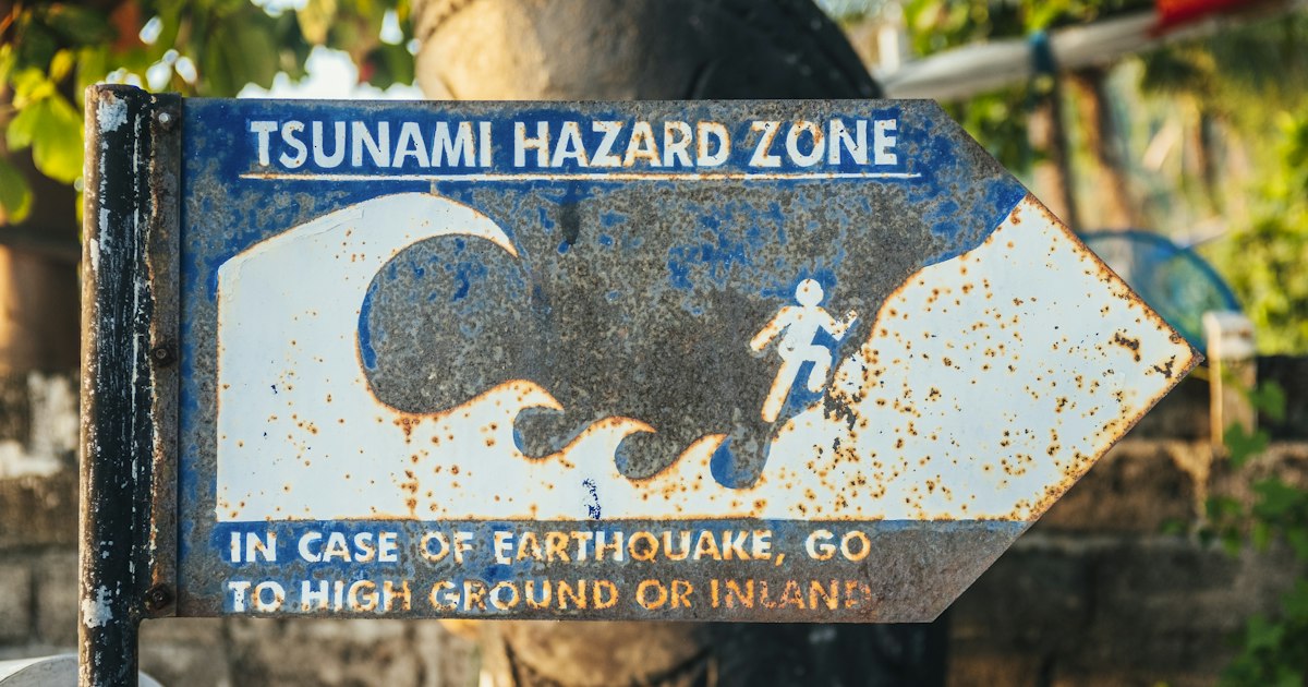
Photo by Bernard Hermant on Unsplash
If you spend any time along Japan’s coastline — a seaside ryokan in Chiba, a surf break in Kagoshima, a ferry terminal in Hokkaido — you will eventually walk past a blue sign with a white wave icon and an arrow. Most tourists glance at it and keep walking. That’s a mistake. These signs are part of one of the most carefully engineered public safety systems in the world, and knowing how to read them in the ten seconds you might actually have takes almost no effort to learn in advance. This guide explains what the signage means, how the evacuation system actually works, and what to do differently than you would at home.
Why Japan standardized tsunami signage
After the 2011 Tohoku earthquake and tsunami, Japan’s government reviewed how inconsistent signage across different prefectures had slowed evacuations. In 2011–2012, the Japan Industrial Standards Committee (JIS) rolled out a unified pictogram system — JIS Z9098 — so that a sign in Okinawa and a sign in Iwate mean exactly the same thing. The core color is blue (not yellow or red), chosen specifically because it’s visible against grey tsunami-warning skies and doesn’t get confused with the yellow/black “tsunami hazard zone” boundary markers or red fire-evacuation signs used elsewhere in the same cities.
The three signs you actually need to recognize
There are three distinct blue-sign pictograms, and the difference between them matters:
- Tsunami hazard zone sign — a wave icon with a running figure, no arrow. This just tells you “you are in an area that can flood in a tsunami.” It’s informational, not directional.
- Tsunami evacuation site (避難場所, hinanbasho) — a wave icon plus a running figure plus a directional arrow and distance. This points toward open high ground or a designated safe zone, often a hillside, park, or elevated plaza. This is the one you follow on foot.
- Tsunami evacuation building (津波避難ビル, tsunami hinan biru) — usually a sign mounted directly on a specific building (a hotel, city hall, or school) showing the wave icon with a building silhouette and often a floor number. These are pre-designated structures tall and strong enough to shelter people above the expected flood height when there’s no time to reach high ground.
The practical rule: if you can see an arrow pointing toward a hill or park, follow it on foot immediately. If you’re in a dense flat area with no visible high ground and a building sign is right there, go up to at least the floor number marked (often 3rd floor or higher) rather than wasting time searching for open ground.
What to do when you actually hear a warning
Japan’s tsunami warnings come through a layered system: J-Alert sirens (a distinctive rising-and-falling tone), a push notification on NHK and most smartphones set to a Japanese carrier or roaming on one, and loudspeaker announcements in coastal towns. The announcement will say either 津波警告 (tsunami warning) or the more severe 大津波警報 (major tsunami warning). You do not need to understand the Japanese — the siren tone alone is the signal to move.
The critical number to internalize: in the 2011 disaster, the first waves reached some coastal towns in under 30 minutes, and in a few cases under 10. That is not enough time to check your phone, gather belongings, or ask at a front desk. The rule drilled into Japanese schoolchildren is “てんでんこ” (tendenko) — everyone evacuates immediately and separately, without waiting to regroup. If you’re staying somewhere near a coast — including places like Kujukuri Beach in Chiba or the remote shoreline around Cape Erimo in Hokkaido — it’s worth spending two minutes on arrival finding the nearest blue sign rather than figuring it out mid-emergency.
Finding the signs before you need them
Most municipal tourism offices and hotel front desks in coastal areas can point to the nearest evacuation route on a paper map (ask for 避難マップ, hinan mappu) — this is free and takes 30 seconds. For a digital option, the “Yahoo! Japan” app and NHK’s news app both push tsunami alerts in English if your phone’s language is set accordingly, and Japan’s Meteorological Agency (JMA) publishes real-time tsunami warnings in English at jma.go.jp. If you’re renting a car or scooter along a coastal road, note that many prefectures have painted blue evacuation arrows directly onto utility poles and guardrails every few hundred meters — these supplement, not replace, the standing signs, and they’re especially useful driving at night.
Island and small-boat destinations deserve extra attention since evacuation routes are shorter and signage sparser. If you’re island-hopping somewhere like Tanegashima, or out on the water via a rented jet ski or a license-free small motorboat, ask the rental staff directly what the evacuation protocol is for watercraft — the standard advice for anyone on the water during a tsunami warning is to head immediately to open deep water rather than toward shore, which is the opposite instinct of what you’d do on land.
Common mistakes visitors make
The most common error is treating the hazard-zone sign (no arrow) as a “nothing to worry about” sign simply because it isn’t pointing anywhere — it’s actually telling you that you’re standing in a flood-risk area and should know your route before an emergency, not during one. The second mistake is driving to evacuate: during real events, coastal roads jam almost instantly, and walking toward the nearest marked high ground is consistently faster. The third is waiting for official confirmation before moving — if you feel a strong or unusually long earthquake near the coast, treat that as the warning itself; official alerts can lag the shaking by several minutes.
Also worth knowing: evacuation signage height markers (a horizontal line on some signs showing historical flood levels, like those found around Tohoku’s coast) are memorials and reference points, not current warnings — they show how high past tsunamis reached at that spot, which is itself a sobering way to judge how seriously to take the designated routes.
The takeaway for trip planning
None of this should make you avoid Japan’s coastline — tsunami warnings are rare events and the country’s preparedness infrastructure is genuinely excellent. The entire ask is small: when you check into a coastal hotel or arrive at a beach town, take sixty seconds to spot the nearest blue evacuation sign and note which direction it points. That’s the same instinct as checking where the emergency exits are on a plane — unlikely to matter, cheap to do, and the one piece of prep that actually counts if it ever does.