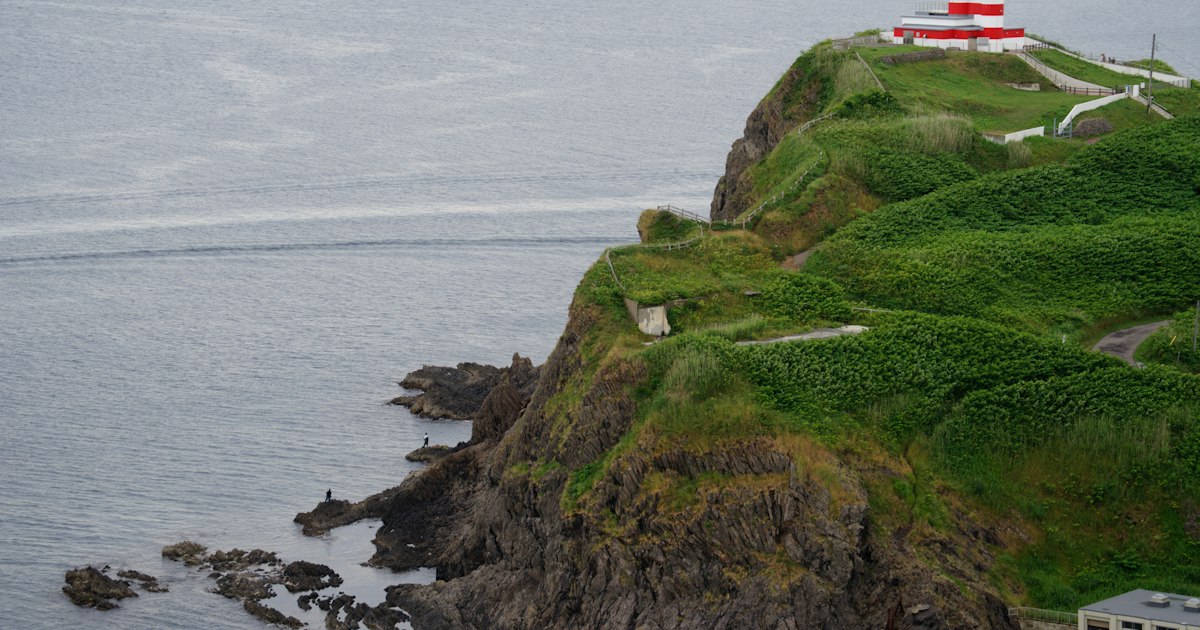
Most visitors to Kagoshima stop at Sakurajima, maybe soak in a sand bath in Ibusuki, and call it a day. Few push on to Cape Sata, the knuckle of volcanic rock at the very bottom of the Osumi Peninsula where mainland Japan runs out of land. That’s exactly why it’s worth the effort: a half-day commitment rewards you with an honest-to-goodness “edge of the country” lighthouse, subtropical coastal forest, and views out toward Tanegashima and Yakushima with almost nobody else around.
Why Travelers Make the Trip to Cape Sata
Cape Sata (佐多岬) is the southernmost point of Japan’s four main islands, grouped with Cape Soya in Hokkaido as one of the country’s “shihō” extremities. Unlike Cape Soya, which has road access right up to the marker, Cape Sata still feels like a frontier — there’s no train anywhere near it, mobile signal gets patchy, and the final approach is a walk through a tunnel and over a forested ridge. The payoff is the Sata Misaki Lighthouse, first lit in 1871 and designed by Scottish engineer Richard Henry Brunton, who built many of Japan’s earliest Western-style lighthouses. The original structure was damaged during WWII and rebuilt in 1950; it’s not open for climbing, but you view it from an observation deck across a small strait, with the open Pacific behind it.
Getting There from Kagoshima: Car, Ferry, or Bus
There’s no way around it — Cape Sata requires either a rental car or a lot of patience with buses.
- Self-drive (easiest): From Kagoshima city, take Route 225/269 down through Kanoya; it’s roughly 130km and takes 2.5–3 hours one way thanks to winding coastal roads, not distance. Fill up on gas in Kanoya or Nejime — stations thin out fast south of there.
- Ferry shortcut: If you’re coming from Ibusuki or the Satsuma Peninsula side, the Nankyu Ferry runs between Yamagawa port and Nejime port across the mouth of Kinko Bay, a crossing of around 50 minutes with several sailings a day. It costs roughly ¥500–600 per adult passenger and about ¥1,500–2,000 for a car with driver, and it saves driving all the way around the bay through Kanoya.
- Bus: Technically possible but impractical for a day trip. A bus connects Kagoshima to Kanoya (around 1.5–2 hours, including the Sakurajima ferry crossing), and from Kanoya a limited local bus continues toward Sata village — but service to the cape entrance itself is sparse, sometimes just a couple of runs a day, and you’ll likely need a taxi for the last stretch. Budget for a taxi charter from Sata or Nejime if you’re not driving.
If you’re road-tripping around Kyushu and like discovering spots most tourists skip, Cape Sata fits the same spirit as Setoda on the Shimanami Kaido — worth the detour precisely because it’s inconvenient.
At the Cape: The Lighthouse, the Toll Path, and What You’ll See
Park at the Cape Sata entrance area and pay the entry fee — around ¥500 for adults, less for children — to access the footpath. From there it’s about a 15–20 minute walk one way through a lit tunnel cut into the hillside, then up a stepped path through subtropical forest to the observation terrace facing the lighthouse. Wear real shoes; it’s humid, occasionally slippery, and not stroller-friendly.
Along the way is the Sata Adan boardwalk, a short nature trail through adan (screw pine), a subtropical plant whose natural range hits its northern limit right here — a small but genuine botanical curiosity. On a clear day, the observation deck gives views past the lighthouse toward Tanegashima and, further out, Yakushima. Hours for the park are generally around 9:00–17:00, but they shift seasonally and the site occasionally closes for weather or maintenance, so it’s worth a quick search for current hours before you drive two and a half hours to get there.
Best Time to Visit
Spring (April–May) and autumn (October–November) are the sweet spots — comfortable temperatures, clearer skies, and a decent chance of actually seeing the outer islands rather than haze. Summer is viable but hot, humid, and sits squarely in typhoon season (August–September), when the whole route can get shut down with little warning. Winter here is mild by Japanese standards — this is subtropical Kyushu — but coastal winds at the cape itself can be sharp, so bring a windbreaker even if Kagoshima city feels warm.
Common Mistakes to Avoid
- Confusing it with Cape Nagasakibana. Near Ibusuki, on the Satsuma Peninsula, is another “southern cape” with a famous view of Mt. Kaimon — but it is not the southernmost point of mainland Japan. That title belongs to Cape Sata, on the opposite (Osumi) peninsula. Plenty of travelers visit Nagasakibana and assume they’ve “done” the southern tip.
- Underestimating the drive time. 130km sounds short; on these roads it isn’t. Treat this as a full day trip from Kagoshima city, not a quick detour.
- Assuming public transport will work. It technically exists but isn’t built for tourists on a schedule. If you don’t drive, budget for taxis on the final leg.
- Skipping the fuel stop. Gas stations are sparse past Kanoya/Nejime, and running low on a peninsula with no train line nearby is a genuinely bad time.
- Arriving too close to closing time. The walk to the viewpoint and back takes 30–40 minutes round trip; don’t roll in at 16:45 expecting to make it.
Where to Eat, Stay, and Spend
Budget: Pack snacks before you leave Kagoshima — options near the cape are limited to a small shop or two in Sata village. If you’re passing through Kumamoto or elsewhere in Kyushu on this trip, a bag of ikinari dango travels well as road-trip food. A self-drive day trip, including fuel and the ¥500 park entrance, can run under ¥5,000 per person excluding the rental car itself.
Mid-range: Combine the cape with an overnight in Ibusuki, using the Yamagawa–Nejime ferry to link the two halves of your loop, and add a sand bath session at Saraku (around ¥1,100) on the way back.
Splurge: Hire a private car-and-driver or taxi charter from Kagoshima city for the full round trip — figure on several thousand yen per hour, easily ¥30,000–40,000 for a full day — which lets you skip the rental car logistics and the ferry timetable entirely.
If you’re the type who tracks Japan’s geographic extremes, it’s worth knowing Cape Sata’s northern counterpart, Cape Soya in Hokkaido, sits near Hokkaido’s Densuke watermelon growing regions — a fun bookend if your Japan trip spans both ends of the country. And if you’re flying in or out through Fukuoka on this Kyushu leg, the city’s Hakata-ori weaving makes a better souvenir than anything you’ll find near the cape itself.